
Friday 15th February
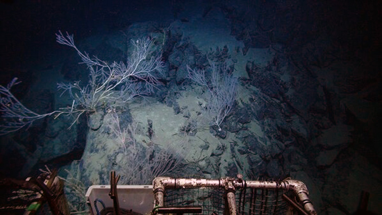
Overnight, Isis dive 202 continued at the Von Damm Vent Field - our last dive planned at that site. We had an extensive task list, including deploying seafloor experiments that will be collected by a Japanese expedition in June/July, thereby revealing what goes on over the intervening months rather than the few days we have here. We also had to collect equipment that we had put down on the seafloor to record data during our dives so far. And as always, each team had just one more piece of data or sample that they wanted, to answer their key questions about these particularly mysterious deep-sea vents here.
So, while aware of the very tight timeline for our overall expedition, it made sense to extend the dive plan by a few hours to ensure that all tasks were completed. Consequently, we have now completed our work at the Von Damm Vent Field, and I hope we have gained useful new insights into a different type of venting on the seafloor.
Farewell to the scenery of Mount Dent
The ship has moved off from its vigil above the upper slopes of Mount Dent, and out over the deeper volcanic rift. We are now holding station over the world's deepest known undersea vents, 5 km below us at the Beebe Vent Field, which we saw for the first time in April 2010.
While the ROV team reconfigured Isis for the next dive to map the seafloor here, the chemistry team deployed the CTD probe to investigate the plume of mineral-rich water dispersing away from these vents. Thanks to an instrument akin to an underwater smoke detector, they were able to track particle-laden water rising from the Beebe Vent Field to more than 1 km above the seafloor.
Most vent plumes only rise a few hundred metres, but here a combinaion of very hot vents and no layering of the water above them may produce that usually large rise height. The CTD probe also collected samples from the vent plume to see how it reacts with seawater and affects the chemistry of the surrounding ocean.
The CTD survey managed to finish a couple of hours early, thereby helping to recoup the extra time allocated to the previous ROV dive. And then at 8 pm local time, Isis dive 203 went into the water. Here at the Beebe Vent Field, the 5 km descent to the seafloor will take more than three hours.
The vehicle will then fly survey lines at an altitude of 25 to 30 metres above the seabed, mapping the terrain in fine detail to prepare for our future dives here, and aid geological interpretation at these vents. The dive should last 36 hours deck-to-deck if we complete all the survey lines, but the expected deterioration in weather may curtail operations slightly. However, the key survey lines are planned for early in the dive, so we may be able to sacrifice some towards the end.
Although there is not much to see during mapping dives because the vehicle flies out of visual range of the seabed, there is some renewed enthusiasm aboard for this task. The 3D map of the Von Damm Vent Field that Tim Le Bas has produced from our earlier mapping dive, assisted by PhD student Leigh Marsh, is utterly stunning.
Every boulder and pockmark that we saw during dives is apparent, and at a glance we can pinpoint exactly where we collected samples and made measurements. It is rare to have such a detailed picture of the deep-sea landscape, and I am looking forward the current dive enabling a similar map for the Beebe Vent Field.